


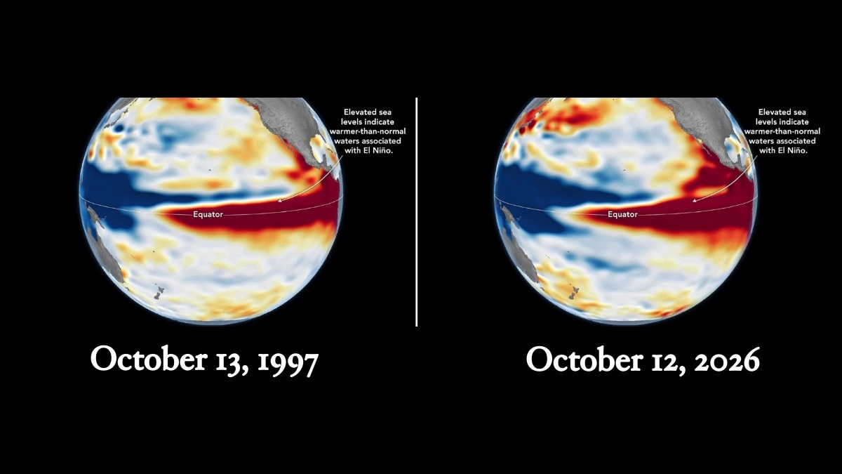
New Delhi: Nasa observations indicate that the developing 2026 El Nino is showing signs of rivaling the powerful 1997-1998 event, which stands as one of the strongest on record. This development raises concerns regarding potentially severe weather disruptions across the globe in the coming months.
Satellite measurements of sea surface heights across the equatorial Pacific reveal that the ongoing event is developing a pattern comparable to the 1997-1998 episode, characterized by unusually warm water spreading eastward toward the South American coast. Researchers note this could trigger weather consequences similar to those observed during the earlier period, though the exact outcomes remain uncertain.
El Nino occurs naturally every two to seven years when water temperatures in the central and eastern equatorial Pacific rise above normal. This warming disrupts atmospheric circulation, altering global rainfall, temperatures, and storm systems.
Historic strong events, such as those in 1997-1998 and 2015-2016, caused extensive disruptions including forest fires in Indonesia and the Amazon, agricultural droughts in southern Africa, and severe precipitation and coastal flooding in Southern California. According to Nasa, while the 2026 phenomenon formed more rapidly than the 1997-1998 instance, the distribution of warm water across the Pacific now bears a striking resemblance to it.
Josh Willis, a project scientist for sea level missions at Nasa's Jet Propulsion Laboratory, remarked that finding a typical El Nino is challenging because every occurrence varies in its thermal development and regional impacts.
To monitor these changes, Nasa researchers rely on satellite altimetry to measure ocean surface heights. Because seawater expands as it warms, elevated sea levels across the central and eastern Pacific highlight the accumulation of heat tied to El Nino.
Comparative satellite mapping from October 1997, October 2015, and October 2026 highlights distinct variations among the events. In 1997 and 2026, elevated sea levels reached toward South America, whereas the strongest anomalies in 2015 stayed further offshore. These spatial differences are critical because the position of ocean warming dictates atmospheric responses and the regional distribution of extreme rainfall.
Nasa's extensive 35-year satellite archive enables researchers to evaluate current conditions against prior major occurrences, with Willis noting that the present event is tracking to be even larger than 1997.
An outlook published on October 8 by the US National Oceanic and Atmospheric Administration projected an 83 percent likelihood that a strong-to-very-strong El Nino will persist through the first quarter of 2027.
Even so, experts emphasize that matching ocean patterns do not ensure identical weather consequences. El Nino operates through an intricate atmospheric framework, meaning its ultimate repercussions can differ substantially from region to region as ocean warming interacts with local atmospheric conditions over the months ahead.