


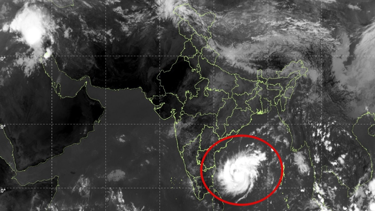
New Delhi: A new cyclone is gathering strength over the Bay of Bengal, and satellite images from space are capturing its gradual intensification as it heads towards India's eastern coastline.
Less than a week after the remnants of Cyclone Arnab swept across central India, another powerful weather system is threatening to bring heavy rain, damaging winds and possible destruction to coastal Andhra Pradesh.
The India Meteorological Department has warned that the deep depression over the southeast and adjoining southwest Bay of Bengal is likely to intensify into a cyclonic storm within the next six hours and further strengthen into a severe cyclonic storm by November 2.
The latest INSAT-3DS thermal infrared satellite imagery shows a well-organised cloud system swirling over the Bay of Bengal, southeast of the Indian peninsula. The developing system has a prominent spiral cloud structure, indicating an organised weather disturbance gaining strength over warm ocean waters.
According to the meteorological agency, the deep depression moved west-northwestwards at around 20 kmph during the three hours preceding its latest update.
At 8:30 am on Sunday, November 1, it was centred over the southwest and adjoining southeast Bay of Bengal. The system was located approximately 630 km east-southeast of Chennai, 710 km south-southeast of Visakhapatnam and 710 km east-southeast of Nellore.
Forecasters expect the system to continue moving west-northwestwards, intensifying into a cyclonic storm over the southwest and adjoining west-central Bay of Bengal before becoming a severe cyclonic storm on November 2.
The most concerning part of the forecast is the system's projected landfall along the Andhra Pradesh coastline.
The meteorological department has warned that the severe cyclonic storm is very likely to cross the south Andhra Pradesh coast between Nellore and Narsapur by the morning of November 3.
At landfall, the system could pack sustained wind speeds of 100-110 kmph, with gusts reaching 120 kmph.
Such winds can damage houses, uproot trees, disrupt electricity and communication networks and make conditions dangerous for people living along the coast.
The approaching system also comes at a time when the Bay of Bengal is witnessing another round of intense weather activity following Cyclone Arnab.
For Andhra Pradesh, the next 48 hours will be critical as meteorologists track the storm's intensity, movement and eventual landfall location.
Satellite observations will remain crucial in monitoring the system as it moves closer to the coastline. Its final intensity and precise landfall location will determine the scale of the impact across coastal districts.