


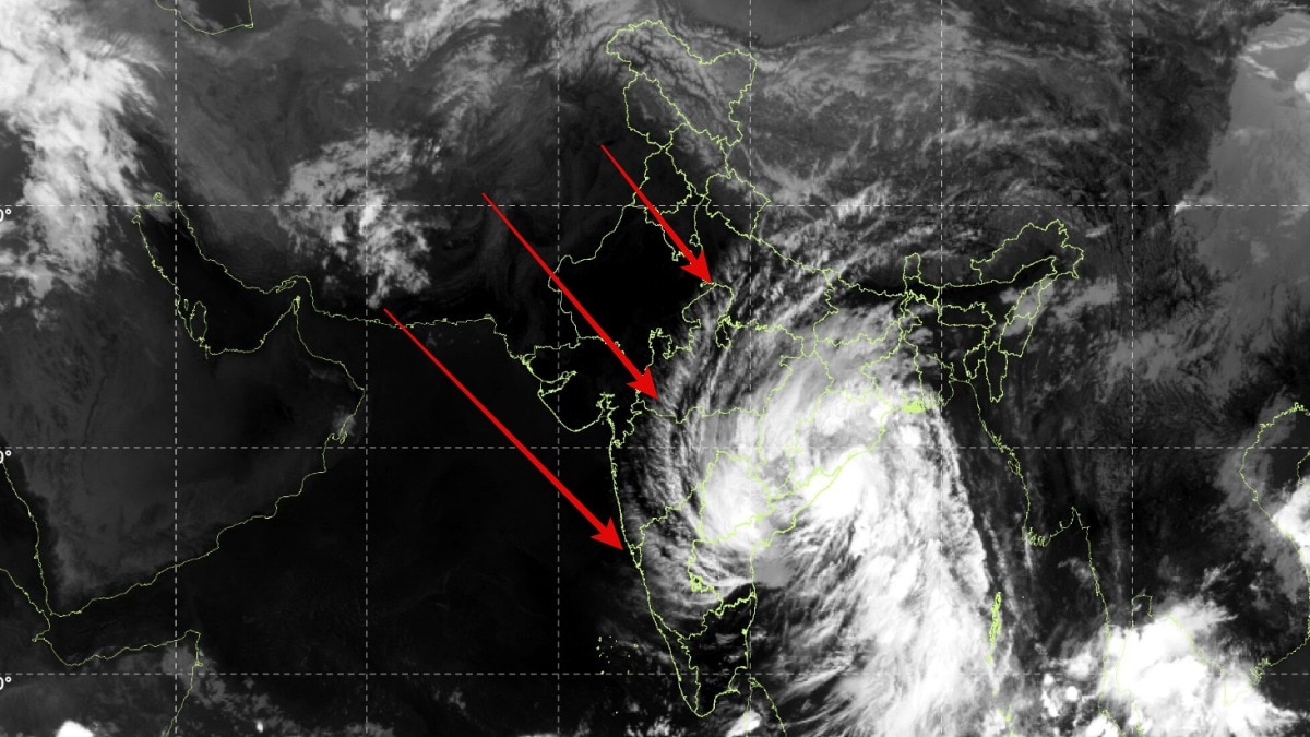
Cyclone Arnab completed landfall along the Andhra Pradesh and Yanam coasts with gusts reaching 150 kmph. Its sprawling rainbands could continue bringing heavy rainfall, flooding and disruption inland.The IMD said the storm maintained maximum sustained winds of 125-135 kmph.
Cyclone Arnab has completed its landfall along the Andhra Pradesh and Yanam coasts, unleashing winds of up to 135 kmph and gusts reaching 150 kmph as its powerful core moved over land, according to the India Meteorological Department (IMD).Satellite imagery from India’s INSAT-3DS weather satellite captured the massive storm system over the Indian subcontinent on Wednesday morning, October 28, revealing its sprawling cloud bands and dense central cloud mass as it interacted with the coastline.The very severe cyclonic storm crossed the coast between 2 am and 8 am IST, with its centre moving inland near latitude 16.45°N and longitude 81.9°E. The landfall location was approximately 20 km east-northeast of Narsapur, 40 km southwest of Yanam and 60 km southwest of Kakinada.Cyclone Arnab is heading towards India's east coast.
Landfall is forecast near Andhra Pradesh and Yanam on 28 October, with sustained winds of 115–125 km/h and gusts up to 150 km/h. Filmed from space 8 hours ago. https://t.co/1nhHEqu38M— sen (@sen) October 27, 2026The IMD said the storm maintained maximum sustained winds of 125–135 kmph, with gusts reaching 150 kmph during the landfall process.
INSAT-3DS CAPTURES THE STORM’S IMMENSE CLOUD SHIELDThe INSAT-3DS thermal infrared image, captured between 9:30 am and 9:57 am IST, shows the cyclone’s broad cloud shield extending across parts of eastern and southern India and the Bay of Bengal.The bright white cloud clusters in the image indicate regions of high, cold cloud tops, often associated with deep convection and powerful thunderstorms. The curved cloud bands surrounding the storm reflect the circulation that draws moist air towards its centre.Thermal infrared imagery allows meteorologists to monitor cloud-top temperatures even when sunlight is unavailable.
Colder cloud tops can indicate thunderstorms rising high into the atmosphere, although the image alone cannot determine the cyclone’s surface wind speed or confirm its exact intensity.The satellite view also illustrates how the storm’s influence extends well beyond its central circulation. Rainbands can deliver intense rainfall far from the landfall point, increasing the risk of waterlogging, flash floods and disruptions across affected districts.LANDFALL PROCESS COMPLETE, BUT DANGER REMAINSAlthough the IMD’s latest observations indicate that the landfall process has been completed, the cyclone’s hazards will not end immediately.
As the system moves farther inland, friction and the loss of its warm-ocean energy source should gradually weaken its winds.However, heavy rainfall could continue across parts of Andhra Pradesh and neighbouring regions, with localised flooding and damage possible. Strong gusts may also bring down trees, damage power lines and disrupt transport.The next critical factor will be the cyclone’s inland track and the amount of rainfall its remaining cloud bands produce.Even after a powerful cyclone crosses the coast, its weakening circulation can continue to pose a serious threat to communities away from the shoreline.- Ends