


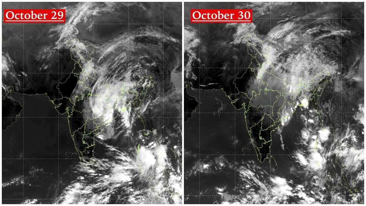
INSAT-3DS images captured Cyclone Arnab moving northwards and weakening over land. The focus now turns to rainfall risks and a fresh Andaman Sea system.The October 29 image shows a large, organised mass of dense clouds spreading across eastern and central India.
By October 30, the satellite image shows the cloud mass continuing its northward movement. Two satellite images captured by India's INSAT-3DS satellite on October 29 and 30 reveal how Cyclone Arnab's cloud system moved northwards across eastern and central India, gradually losing its strength after making its way inland from the Bay of Bengal.What began as a Very Severe Cyclonic Storm has now weakened considerably, with the India Meteorological Department (IMD) reporting that its remnants have transitioned into a well-marked low-pressure area over central Chhattisgarh and adjoining Odisha.The October 29 image shows a large, organised mass of dense clouds spreading across eastern and central India, with the system's cloud bands extending towards the northeastern parts of the country.
The cloud formation is particularly prominent over Odisha, Chhattisgarh, Jharkhand, West Bengal and adjoining regions.By October 30, the satellite image shows the cloud mass continuing its northward movement, with the system's circulation appearing less organised. The cloud cover remains extensive across parts of eastern and northeastern India, but the structure has become more diffuse compared with the previous day's image.
The change is consistent with the IMD's latest assessment issued at 9:15 pm on October 29.According to the weather agency, the depression, which was the remnant of Very Severe Cyclonic Storm Arnab, moved nearly northwards and weakened into a well-marked low-pressure area at 5:30 pm on October 29 over central Chhattisgarh and adjoining Odisha. The IMD expects the system to continue moving north-northeastwards and weaken further into a low-pressure area over northeast Chhattisgarh and neighbourhood during the next 24 hours.FROM A VERY SEVERE CYCLONE TO A LOW-PRESSURE AREAThe weakening marks a significant transformation of Arnab, which had earlier developed into a very severe cyclonic storm over the Bay of Bengal.
As the system moved inland, it encountered conditions that gradually weakened its circulation and reduced its ability to sustain intense winds.However, weakening does not mean the weather threat has completely disappeared. The remnant circulation and associated moisture can continue to trigger rainfall and thunderstorms across parts of eastern and central India.ANOTHER SYSTEM BREWING OVER THE ANDAMAN SEAThe October 30 satellite image also reveals a separate area of intense cloud activity over the South Andaman Sea and adjoining regions.The IMD has identified this as a low-pressure area, designated as system A in its latest weather bulletin, while Arnab's remnants are being tracked separately as system B.The development is worth monitoring as atmospheric conditions over the Bay of Bengal remain active.Together, the two satellite images capture the changing weather landscape over the Indian subcontinent: one cyclone completing its journey as it weakens over land, while another area of disturbed weather develops over the Andaman Sea.For meteorologists, the focus now shifts from tracking Arnab's intensity to monitoring its rainfall impact and the possible evolution of the fresh system over the Bay of Bengal.- Ends