


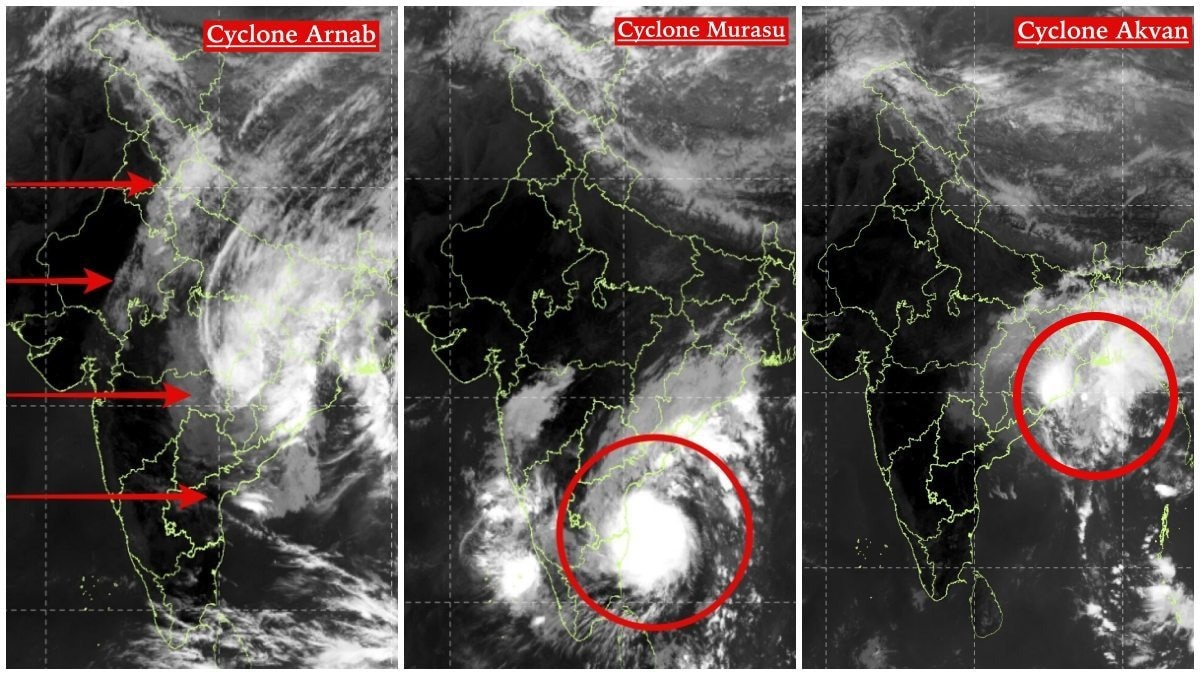
INSAT-3DS images reveal contrasting structures in cyclones Avkan, Arnab and Murasu. The differences show how storms from one basin can vary in intensity and spread.Satellite images of three cyclones taken from space by Isro.
India has witnessed three cyclonic systems making landfall or affecting its coastline within a month, but satellite images reveal that the storms were far from identical.From their cloud structures and geographical positions to the way their circulation systems interacted with surrounding weather, Cyclones Avkan, Arnab and Murasu presented three different atmospheric patterns.INSAT-3DS thermal infrared imagery offers a closer look at these differences. The images show how each system evolved over the Bay of Bengal and surrounding regions, highlighting why not every cyclone follows the same structure or produces the same weather impacts.FOLLOW CYCLONE AKVAN LIVE UPDATES Three storms, three different structures Cyclone Akvan as it makes landfall.
The first image, captured by INSAT-3DS on November 20, shows Cyclone Akvan around the time it crossed India's eastern coastline. Unlike a tightly organised cyclone, its cloud structure appears relatively asymmetric, with a large area of dense convection extending over eastern and northeastern India.
The cloud mass is spread across a wider geographical area, suggesting that its weather influence extended beyond the immediate storm centre.Akvan made landfall on India's eastern coast on November 20, bringing winds of 70-80 kmph, with gusts reaching 90 kmph. It had weakened overnight before crossing the coast.
The giant swirls of Cyclone Arnab seen from space. Cyclone Arnab, seen in the second satellite image, presents a different picture.
Its cloud formations are broad and sprawling, with extensive bands stretching across the Bay of Bengal and towards the Indian peninsula.The red arrows in the image highlight the interaction of the surrounding cloud and weather patterns with the cyclone's extensive cloud shield.Arnab was also the strongest of the three at landfall. It crossed the Andhra Pradesh and Yanam coast on October 28 as a Very Severe Cyclonic Storm, packing sustained winds of 125-135 kmph and gusts reaching 150 kmph.
Its extensive cloud structure reflected a widespread zone of disturbed weather.Cyclone Murasu, captured in the third image, looks markedly different. Its cloud formations are comparatively compact, with a concentrated, bright central region surrounded by curved cloud bands.
Cyclone Murasu as it comes close to the Indian coast. The red circle highlights the dense convective core, indicating a more concentrated organisation of intense cloud activity at the time of observation.Murasu crossed the south Andhra Pradesh coast near Ongole during the early hours of November 3 as a Severe Cyclonic Storm, with sustained winds of 100-110 kmph and gusts reaching 120 kmph.WHY THE DIFFERENCES MATTERAll three cyclones originated over the Bay of Bengal, but their satellite signatures demonstrate how differently tropical weather systems can organise themselves.Arnab had the strongest winds at landfall and a sprawling cloud shield.
Murasu displayed a relatively concentrated zone of intense convection, while Akvan's November 20 imagery showed an extensive, asymmetric cloud distribution around its landfall period.Thermal infrared imagery from INSAT satellites helps meteorologists observe cloud-top temperatures and identify areas of deep convection. Brighter cloud regions generally indicate colder cloud tops, often associated with powerful thunderstorms.However, satellite cloud patterns alone cannot determine a cyclone's wind speed or intensity.
That requires additional observations from weather radars, ocean buoys and other meteorological instruments.The larger takeaway is that three cyclones striking India's coastline within a month do not necessarily behave alike. Their intensity, cloud organisation and geographical spread can be dramatically different, even when they develop over the same ocean basin.- Ends