


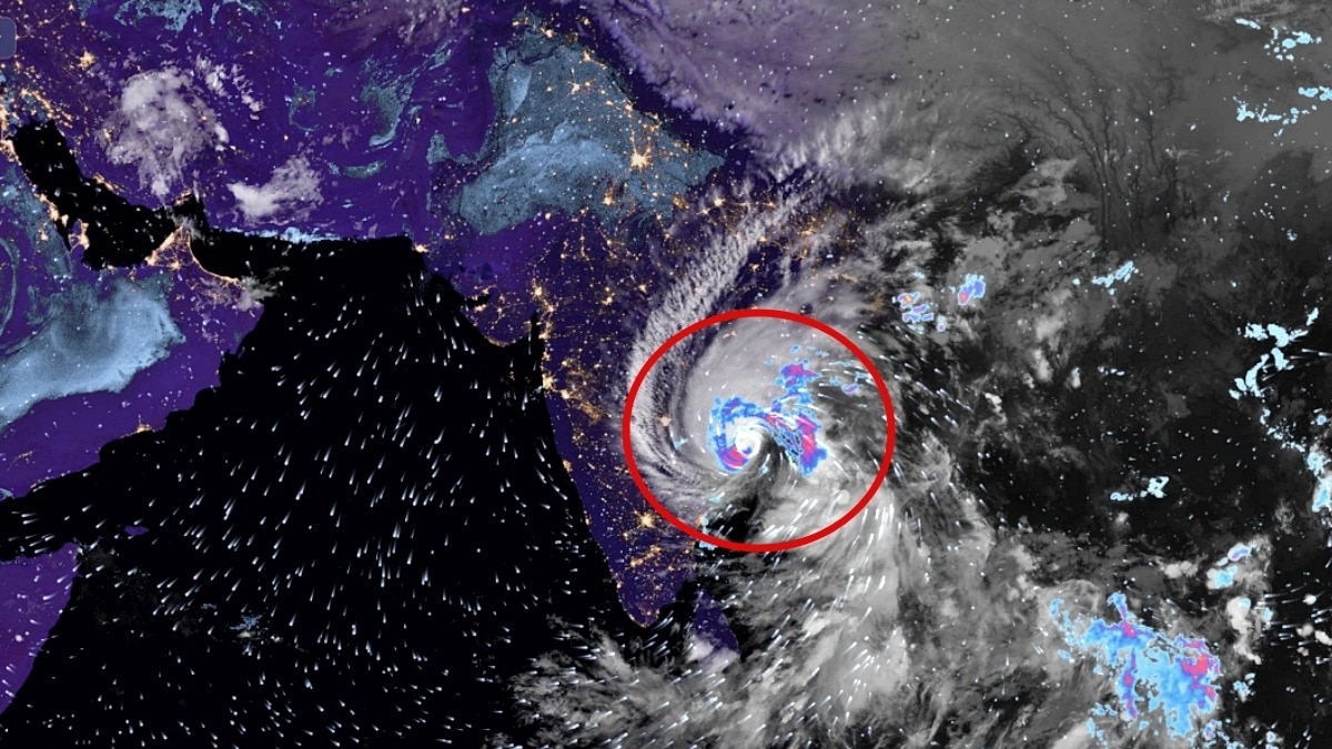
Cyclone Arnab rapidly intensified into an exceptionally powerful and compact storm over the Bay of Bengal before making landfall, raising concerns over its potential impact on Andhra Pradesh. Its sudden strengthening has also highlighted the challenges forecasters face in predicting how quickly tropical cyclones can intensify.The very severe cyclonic storm made landfall during the early hours of October 28, between 2 am and 4 am IST, according to the forecast information provided.
Its outer spiral rainbands had already begun interacting with land, while its faster movement brought the expected landfall sooner.The storm's rapid intensification has raised concerns because several forecasting models reportedly failed to anticipate the extent of its strengthening. Windy Official estimates also appeared to underestimate its intensity until only hours before the expected landfall, leaving a narrower window to assess the threat.
Although interaction with land, ocean upwelling and changes in atmospheric wind patterns could weaken Arnab before it reaches the coast, the extent of that weakening remains uncertain. Even a weakening cyclone can produce destructive winds, torrential rainfall, coastal flooding and dangerous inland inundation.FOLLOW CYCLONE ARNAB LIVE UPDATESWHAT IS A CATEGORY 4 “DRILLBIT” CYCLONE?
The term “Category 4” comes from the Saffir-Simpson Hurricane Wind Scale, which classifies storms using their maximum sustained winds.Category 4 hurricanes have winds of approximately 200-250 kmph. The scale is widely used for Atlantic and eastern Pacific hurricanes, but India’s IMD uses a different classification system for cyclones.“Drillbit” is an informal descriptive term, not an official meteorological category.
It refers to a compact, tightly wound storm with a sharply defined core, resembling a rotating drill bit. Such systems can concentrate destructive winds around a relatively small area.The IMD's published forecast identified it as a very severe cyclonic storm, with sustained winds of 115-125 kmph and gusts reaching 140 kmph.
A super cyclonic storm under India's classification requires sustained winds of at least 222 kmph.WHY DID CYCLONE ARNAB INTENSIFY SO QUICKLY?Tropical cyclones draw energy from warm ocean water. When seawater evaporates, it loads the atmosphere with moisture.
As this moist air rises and condenses into clouds, it releases latent heat, strengthening the storm's circulation.Several factors can accelerate this process:Warm ocean waters: High sea-surface temperatures and abundant ocean heat provide the energy and moisture needed for intensification. El Nino has made ocean waters warmer, which could be adding energy to the entire system.Low vertical wind shear: When winds at different atmospheric heights are relatively aligned, the storm can maintain a more organised structure instead of having its thunderstorms blown away from its centre.A compact core: A tightly organised inner circulation can allow wind speeds to increase rapidly as the pressure falls and the system strengthens.What’s happening near India right now is slipping under a lot of headlines.
Cyclone Arnab appears to have just explosively intensified into a violent, compact, Category 4 drillbit. He is moving straight towards the dense populations of Andhra Pradesh, and could be nearing CAT 5 (AKA Super Cyclonic Storm) intensity as we speak.
He’s less than 18 hours away from making landfall. Now, a combination of upwelling, shear, land interaction, and the onset of an EWRC should definitely weaken Arnab before he hits land.
But this is still becoming a VERY dangerous situation, and that’s not even counting the inland flood threat from torrential rainfall.— Backpirch Weather (@BackpirchCrew) October 27, 2026Favourable atmospheric conditions: Moist air, strong thunderstorms and efficient heat release can help a cyclone intensify over a short period.Forecasting such changes remains difficult because ocean conditions, atmospheric shear and the storm's internal structure can change rapidly. Satellite observations help meteorologists track these developments, but uncertainty remains, particularly when a cyclone strengthens over open water.WHAT HAPPENS NEXT?As Arnab hits land, friction, reduced access to warm ocean water, and interaction with the coast should eventually weaken it.
Ocean upwelling can also bring cooler water to the surface, reducing the energy available to the storm.An eyewall replacement cycle, if one develops, can temporarily alter its wind structure and intensity.But weakening does not eliminate the danger. Heavy rainfall could trigger flash floods and inundation well inland, while strong winds and coastal waves threaten communities along the storm's path.- Ends